

CalEPA Headquarters Building
1001 I Street
P.O. Box 2815
Sacramento, CA 95814
There are many ways to arrive at the Joe Serna Jr. CalEPA Headquarters Building. Use the information below, or also check other options at Sacramento Regional Transit’s transportation links page. There are also 25 bike parking spaces for visitors located at two sites in the courtyard.
Visitors Check-in
The California Environmental Protection Agency Building is a secure building. Visitors must check-in at the guard station as they enter the building. They must sign in and receive a temporary badge and must sign out as they leave the building. The guard will contact the CalEPA staff for the visitor so they can escort the visitor through the building.
By Air
Sacramento County Airport System is a 20 minute drive from downtown Sacramento. There are several transportation options from the airport to the CalEPA Building.
YoloBus has a bus route leaving the airport every hour from Terminal A and Terminal B at approximately 10 minutes after the hour from 7 a.m. to 10 p.m. You stand at the Public Transportation Bus Stop. The route takes approximately 18 minutes to get from the airport to 9th and K Street. This is 2 blocks from the CalEPA building. The return trip from 9th and K Street runs approximately 5 minutes after the hour and takes approximately 20 minutes to arrive at the airport. (800) 371-2877.
SuperShuttle Sacramento is another transportation option to and or from the Sacramento Airport. Please provide them with a 24-hour notice to arrange for pick-up service from the CalEPA building. (800) 258-3826 or (800) BLUEVAN
If you are renting a car, see the driving instructions below.
By Train
The Sacramento Amtrak train station is at 401 I Street, six blocks from the CalEPA Headquarters building. Amtrak’s Capitol Corridor trains operate between the Bay Area and Sacramento with many trains daily. Amtrak California’s San Joaquin trains and motor coaches connect the Central Valley from as far south as Bakersfield (and further with their motor coach system) to Sacramento. Other Amtrak trains serving Sacramento include the Coast Starlight and the California Zephyr.
Regional Transit’s light rail serves the train station every 15 minutes seven days a week. RT bus routes also link the Station to downtown government offices and the rest of Sacramento County.
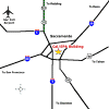
By Car
“Get Directions (Google maps)”
Click on maps for larger image of Sacramento area maps.
Freeways Downtown Streets
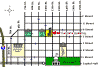
Parking
Metered Parking (1, 2, and 10-hour meters) available near the CalEPA building. Meter parking uses quarters (some meters may use special “debit cards”).
Parking lots are also available in several nearby locations. The closest lot is across from the building on 10th & I Street.
Downtown Sacramento Partnership —Getting Around.